During our conversation about Indian navigation pioneer MapmyIndia, Sid Talwar, a venture capitalist who had bet big on it almost a decade ago, sounds a little too enthusiastic about the company’s prospects. His fund Lightbox backs a whole gamut of tech start-ups — Cleartrip, Greendust, InMobi, ZoomIn, Kotak Urja and Info Edge, among others. And yet, the one company in whose business Talwar sees a distinct edge is MapmyIndia.
“If you look at India, no local mapping company has emerged here. To be able to create this kind of intellectual property (IP) — that is, map base data — in India, is unheard of.” In 2007, when Lightbox invested in CE Info Systems, the parent company, the rationale, in Talwar’s words, was, “We were investing in the opportunity to create detailed maps of the country.” At that time, Indians were still getting used to web 2.0; e-commerce and smartphones were not heard of. Today, however, the story has completely changed.
Maps are becoming increasingly critical for both businesses and individuals. The Indian location-based services (LBS) market was hardly worth ₹50 crore about seven years ago. Contrast that with today, when it is estimated to be a ₹2,000 crore market. “Whether you are a taxi aggregator or an e-commerce player, the question is how do you get your next hundred million customers? Or even reach out to the present hundred million? If you are a cab company, how do you find house number 415?,” Talwar cites the extent of the opportunity in the maps business.
Other investors must have come to a similar conclusion, as Lightbox’s funding in MapmyIndia was followed by another $30 million being poured in over the next four rounds by Nexus Venture Partners, Qualcomm Ventures and Zenrin, a Japanese firm engaged in the production and sale of map databases. “Till 2006, we were a ₹3-crore company. Now, we are in the ₹100 crore range,” says Rakesh Verma, founder and MD, MapmyIndia.
The company is reported to have grown at 35% last year and has an order book of ₹200 crore in the current year. In terms of verticals, MapmyIndia addresses four key markets — direct consumers (through free and paid app/maps), automotive (40% of revenue), mobile internet (20%) and enterprises and government (40% of revenue). While MapmyIndia really took off post its 2007 fund infusion, the venture had started two decades back in 1995, right in the middle of the liberalisation push. Verma and his wife Rashmi were techies who worked in the US and returned to India in 1994 to set up India’s first digital mapping venture. “I had the conviction that digital maps will change the quality of life of individuals as well as help businesses and the government improve productivity and reach out to customers,” says Verma.
Charting its path
Mapping by itself is a never-ending exercise. Which is why the gigantic task of digital mapping took the couple almost 10 years, “After which we could say that we had reached the length, breadth and a reasonable depth of the country,” quips Verma. The business managed to generate enough revenue to bear employee and other costs during this period, thanks to what professor John Mullins in the Harvard business Review (HBR July-August 2013) calls the ‘standardise and resell model’ – the company took advance funding from its customers in the early days to create quality maps.
The customers had problems of their own: in 1993, Coca-Cola acquired Thums Up and found itself in a fix. Thums Up had a complex network of bottlers, each with an assigned distribution territory, but nothing depicted the boundaries of their territories. There were no accurate maps. Similarly, telecom entrants for a better and wider coverage struggled to figure out where to place cell phone towers. MapmyIndia approached these companies and obtained contracts to create digital maps that contained specific information (bottlers’ territories) or topographic features (higher ground, suitable for cell towers).
The advance funding enabled it to make high-quality maps that it could later modify and sell to other clients, including the Indian defence department. “The strategy of winning a contract to create something for one customer and then reselling a variant on a wider scale can work well for small firms in the initial years,” says professor Mullins in the HBR. Bill Gates had adopted a similar strategy for Microsoft in its initial years.
The company moved from project to project and kept augmenting its map base data. “We knew that mapping this country would take ten years. In those ten years, we worked with 50 clients, from Coca-Cola to Unilever to cellular companies, who did not distract us from our end goal but accelerated us,” recalls Verma.
However, in 2004, he realised that the time had come for a transition. “It was time to move from being a passionate entrepreneur to becoming a business entrepreneur,” he says. Verma had some ideas at hand to monetise his offerings in a better way, the first one being to take his maps online. MapmyIndia realised that the digital maps market was a crowded one and that it was only a product company. The only thing that could differentiate it from the crowd was a brand.
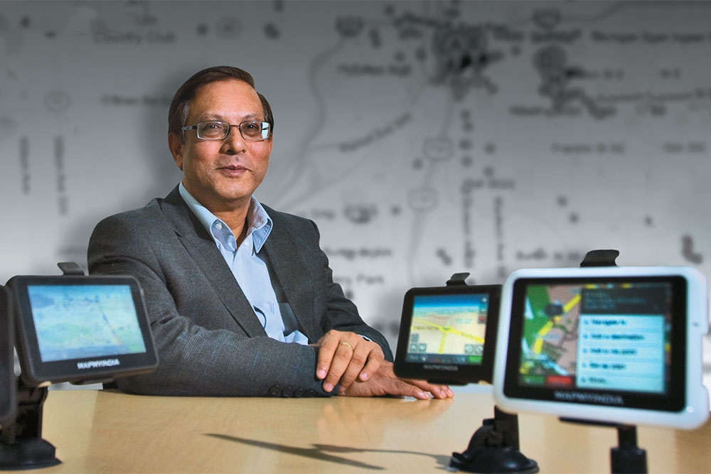
The founders thought that MapmyIndia was a perfect brand name that could connect them with the people. So, India’s first mapping website — MapmyIndia — was launched in September 2004. Within months, it was getting 5,000-6,000 unique visitors a day. The second idea was to bring digital maps to devices to help people navigate. It started from portable navigation devices (PNDs) in the early years to car-mounts and smartphones later — now, it puts maps directly into a car’s dashboard infotainment system. “It was a turning point for the company,” says Verma.
In fact, some investors felt that the company shouldn’t have entered this space on its own because there were several international companies making these products. Since this FMCG approach was unconventional for a company of MapmyIndia’s size, it hired 150 people on the ground to engage with customers back in 2007. At that time, map companies mostly did B2B business in India and customer engagement was not common in the industry.
In an earlier interview, Verma explained, “When we started selling devices in 2007, we invested in educating the market, we hired sales people on the ground. This built long-lasting value. When people went to buy our products, we had a guy at the retail point. That organically created, and helped perpetuate, what GPS was. We didn’t shy away from educating the market even though our size was an obstacle here… Investing in a market before it’s even born is what forerunners do. That has had a lasting brand impact — our customers associate these products with us.”
Auto-motivated
Today, it is the automotive vertical (which includes navigation and tracking) that is driving MapymyIndia’s revenues. Says Verma, “We have always believed connectivity is bound to remain an issue in this country. So, our navigation applications are independent of data,” he says, adding that the applications rely on GPS instead.
Verma has marquee customers such as BMW, Toyota, Tata, Mahindra and Honda using MapmyIndia’s application or devices in their cars, with some competition from Nokia’s Here and TomTom. But he claims that his company is deeply entrenched in the market and has an 80% market share in the automotive navigation segment, with 15 OEMs as its clients. The car companies license the navigation applications from MapmyIndia for a fee.
Verma agrees that his company misses out on a chunk of the market as the likes of Maruti and Hyundai have not yet put screens in their ₹3-lakh-5-lakh range models due to high costs but the company has managed to create a breakthrough with Tata Motors, which recently launched two new models. “Tata Bolt and Zest are not high-end cars. So, the company didn’t want to increase the car’s cost by a huge amount. We told the company, ‘Your customers are Android users. We are giving you an app that can be synced with the car’s entertainment screen.’ And we managed to solve the problem,” he says. The effort seems to be paying off as MapmyIndia is also in talks with Maruti. “When Tata launched the Syncable system in Bolt, Maruti did feel a little left out.”
However, the going in the automative market won’t be easy feels Amit Prasad, founder and MD, SatNav Technologies, who had exited the GPS devices market four years ago. “Korean and Japanese OEMs have global relationships. It is only a matter of time before they say that their global partner data is at par with local partners. Then they just might go with the global partner,” says Amit Prasad. Verma, though, doesn’t agree — he believes that the opposite is going to happen. “Over the past five years, in Japan, China, South Korea and India, global map players have almost been ousted by local players.”
For now, the automotive vertical is the lynch pin in the company’s growth by ensuring a consistent flow of revenue. “In the automotive segment, you have to work very hard. But once you have entered the market, nobody will be able to kick you out. Then it’s only the service teams that have to work on maintaining industry relationships. If Tata sells 1 lakh cars over a period of time, I get that multiplied by our licence fee,” points out Verma. But with people increasingly checking route maps on their smartphones these days, the challenge for Verma is clear: the automotive business could start shrinking as GPS Devices for cars become passé.
With the standalone GPS device market diminishing, the company is now putting its applications directly inside a vehicle’s dashboard infotainment system. Not surprising that revenues from sales of products decreased by 23% in FY14. The only ray of hope in this business remains the dashboard infortainment systems.
Says Prasad, “There might be a few crores to be made today but as you go forward, the entire business model is going to change. In-dash devices running on Android are going to become the norm from next year.” Verma agrees with the same. Add to this the fact that mass-market models of cars are not supplied with inbuilt screens/entertainment systems. “If you compare the growth rate of the smartphone vis-à-vis navigation devices, yes, smartphones are growing faster. But the number of dash maps is going up as well,” points out Verma.
The company, though, is looking at avenues outside of the automotive vertical to keep the momentum going.
New horizons
In 2008, Metro Cash and Carry India was looking for a solution to help accurately estimate customer potential in new markets. “It was important to get this done at an affordable cost and with an audit trail. MapmyIndia helped us accurately estimate a city’s market potential and is widely regarded at MCC internationally as one of the best solution providers for such an assessment,” says the India spokesperson of Metro Cash and Carry.
The ticket size for such enterprise projects are small – ₹2 crore, ₹1 crore or, sometimes, even ₹50 lakh and, unlike the automotive sector, there are quite a few competitors, including the big names such as TCS or Infosys. However, enterprise projects are one-off assignments and, together with government projects, constitute 40% of the company’s revenue. During the past four to five years, MapmyIndia has served nearly 1,000 enterprises.
The company is now trying to become a part of the e-commerce ecosystem, working with Ola Cabs, TaxiForSure and Avis Car Rental. “From the delivery perspective, without good locations, elements, good-quality maps and a strong database at the building level, no mobile internet company will succeed,” says Verma. For example, Avis is a corporate car company and operates differently from a customer like OLA when a booking is made. The car driver and vehicle are usually at different locations. In the past, the driver would have come to the car rental company’s office, collect his job order and left.
But with MapmyIndia solution, he gets the job order, pick-up point and drop-off point on his mobile phone. The vehicle is navigation-enabled and can be tracked from the control room. “In the past, it would take 15 days for the rental service to hand over the bill to the corporate. Now, the moment the invoice is generated, it automatically goes to the corporate. This leads to direct productivity gains and the security of the passengers is ensured,” says Verma.
Further, the entire geospatial industry has its hopes pinned on the government’s 100 ‘smart cities’ project. Finance minister Arun Jaitley’s maiden budget soon after the NDA came to power in 2014 allotted ₹7,060 crore for smart cities. Looking to capture a slice of the upcoming opportunity, Verma points out that MapmyIndia has a solution for smart cities.
Three years ago, the West Bengal government, after a hospital fire incident, decided to upgrade its fire department. MapmyIndia delivered a solution that involved a control room, where, whenever a fire alert is raised, staff can actively track devices on vehicles to determine which one is available closest to the fire. “The control room just sends the latitude and longitude of the place of the incident, the shortest route and the closest hydrant to the vehicles. All this is part of the smart city plan,” says Verma.
However, for now, the smart city potential is a pie in the sky. Besides, there is a lot of competition in obtaining tenders for government projects, and sometimes tenders are jointly awarded, too. Recently, for a Greater Noida power project on consumer billing, Accenture, TCS and MapmyIndia were all in the fray. The government selected Accenture and MapmyIndia and said MapmyIndia should take lead because it is a map company. Accenture was required because the project was to be done on SAP.
Vishal Agarwal, a map aficionado who runs Spatial Ideas, a geospatial solutions company in Mumbai, says, “More than companies like MapmyIndia, it will be application developers who will benefit from the smart city project. It will be unwise for the Indian government to buy base data. Hyper-local data will be more important in a smart city.” He elaborates with an example, “Pointing to a hospital on a map is not good enough. A smart city must have elements like – which hospital has vacancy, which one is better for which treatment, etc.” On his part, Verma says he is looking for interesting start-ups in the hyper-local space to engage with.
Taking on the giant
Uber recently acquired two of Microsoft’s location-based businesses – relating to advertising and search capability. “Uber has found so much value in location-based apps. The explosion of verticals will make location and maps more important,” feels Prasad.
The challenge for MapmyIndia comes from the world’s favourite map company — Google. But Verma is not reading too much into it. “There are certain fundamental differences. Google has several properties, of which maps is one. I am not subsidising through other businesses,” he says.
But Agarwal of Spatial Ideas thinks Google can’t be challenged. “I don’t know about the quality of MapmyIndia’s maps but the best maps for India are Google’s open street maps.” At the end of the day, map base data repository is the company’s IPR and Verma claims that only his company and Google have original map base data for India.
But Prasad counters this claim, “There are 50 people who have map base data — that is not a differentiator. Players such as Google, Tele Atlas, Nokia, Binge and TomTom are the companies that are constantly investing to keep the business updated. Among them, whoever has the right delivery model will succeed.” According to experts, maps are not the key in this business, maps connected with social media, Android and hyper-local data are. Verma defends his business by drawing an analogy with Microsoft Windows, “Base data floats around like the Windows OS. It is licensed but there are leaks which end up in the market.”
Also, Google doesn’t share its maps with enterprises; it employs the API model instead. “If you are someone like Uber and you are not charging your customer for using your app, you can use Google’s maps on your site for free. But if you have a commercial application, you need to pay for Google’s API (Application Program Interface),” says Agarwal.
MapmyIndia has entered the API market only recently. Before defending its late entry in this market, Verma vouches for the quality of the company’s maps, “International auto OEMs using our maps is a certificate of approval. Earlier, enterprises had no choice. Now, the country has a choice. People will automatically pick up the service that is better,” he says. Doesn’t the company’s late entry into API bother investors? “As I looked at MapmyIndia, I was more concerned about accuracy and data development. If the quality is good, missing the API market by a year or two doesn’t matter. We are relevant to many players today who didn’t exist five years ago,” says Talwar.
While the first round of fund infusion into the company through convertible preference shares happened at ₹81 a share in August 2006, the last round of placement in 2011 to Zenrin was done at ₹630 a share. Clearly, investors are buying into the growth story of MapmyIndia. Incidentally, though the company refused to share its financials, filings with the Registrar of Companies show that sales have fallen 12% from ₹69 crore in FY13 to ₹60 crore in FY14, while profits have fallen from ₹1.8 crore to ₹80 lakh over the same period.
The management attributes the drop in revenue to a dip in the automotive market a few years ago. “We have since bounced back significantly. The company is securing strong contracts, thanks to deals with leading e-commerce, technology and enterprise customers. As demand from these segments continue to grow, we should be able to ride the wave,” explains Verma.
The company claims to be on course to achieve ₹125 crore revenue in the current fiscal. “Profits have grown substantially too, as revenues significantly outgrow the fixed cost base, on a high profit margin licensing/software-based business,” adds Verma,
Though the convertible preference shares are due to be converted into equity shares over 15 years to 20 years from the respective date of allotment, there is also an option for investors to exit through an IPO. Some media reports have indicated that Lighbox is trying to exit MapmyIndia. Talwar though sounds non-committal. “We are very happy with how MapmyIndia is doing currently but we are a venture fund and venture funds sell their investments at the appropriate time, hopefully making some money. We are always open to discussing potential fund raising, liquidation and partnerships for our portfolio companies across the board.”
Verma, on his part, is trying hard to lead his passion-turned-business in the right direction. “All milestones in the financial side of the business, including a possible IPO, are a part of the journey and not the destination itself. We are pursuing our long-term vision of bringing the benefits of maps and location to just about everyone.”
At the end of the day, just like any other businesses, cartography too is being disrupted by new technologies. As navigation devices lose their physical contours and emerge in an embedded avatar, MapmyIndia will have to keep looking at alternative routes to reach its final destination. In mapping geographies, Verma clearly cannot risk becoming a part of history.


